Geography MCQ Quiz - Objective Question with Answer for Geography - Download Free PDF
Last updated on Nov 17, 2023
Latest Geography MCQ Objective Questions
Geography Question 1:
Which of the following is not a high population density region of North Africa and South-west Asia?
Answer (Detailed Solution Below)

Geography Question 1 Detailed Solution
- The climate and physical geography of North Africa and Southwest Asia have shaped population patterns and culture in the region.
- People in the region are generally clustered around the region’s scarce water resources reflecting ancient patterns of human settlement.
- Four regions in particular stand out as having high population densities:
- The Nile River valley
- The coastal Mediterranean Sea
- The Euphrates and Tigris river basins
- Valleys of northwestern Iran
- Hence Option D is the correct answer.
Geography Question 2:
Seasonal changes is caused by which one of special characteristic of Earth's motion?
Answer (Detailed Solution Below)
Geography Question 2 Detailed Solution
The formation of seasons takes place due to the revolution and the Tilt of the Earth.
 Important Points
- The movement of the Earth around the Sun in orbit is known as revolution.
- The Tilt of the Earth or the Axial Inclination is about 23.5 Degree i.e the Earth's Axis from North to South leans with the plane of its orbit, the Ecliptic around the Sun, and always points in the same direction.
- The tilted earth's face towards the sun receives more sunlight and longer days and witnesses summer.
- While the other tilted face of the earth is away from the sun and receives less sunlight and has shorter days. This portion of the earth witnesses winter.
- On June 21, the summer season at its peak when the North pole is tilted towards the sun and the Northern Hemisphere receives more sunlight and longer days in comparison to the southern hemisphere and this is termed as the Summer Solstice.
- On 23 September, it is Autumn Equinox when both the poles are not inclined to the sun and the Northern Hemisphere witnesses autumn and the Southern Hemisphere has spring.
- On 22nd December, the South Pole is tilted towards the sun and the Southern Hemisphere witnesses summer while the Northern Hemisphere experiences winter and is termed as the Winter Solstice.
- On March 21, it is Spring Equinox when both the poles are not inclined to the sun and the Northern Hemisphere witnesses spring and the Southern Hemisphere has autumn.
Hence, we can conclude that the revolution of the earth and tilt of the earth causes seasonal changes.
Geography Question 3:
A geographic region has the following distinct characteristics:
1. Warm and dry climate summer
2. Mild and wet winter
3. Favourable for orchard farming
The above features are distinct characteristics of which one of the following regions?Answer (Detailed Solution Below)
Geography Question 3 Detailed Solution
- The Mediterranean climate is characterised by clear skies and high temperatures. The summers are hot and dry, and the winters are cool and wet.
- Mean annual precipitation ranges from 35-90 cm. Temperature of the warmest month is greater than or equal to 10° C.
- The Mediterranean lands are also known as the world’s orchard lands. The Mediterranean lands account for 70 per cent of the world’s exports of citrus fruits. The olive tree is probably the most typical of all Mediterranean cultivated vegetation.
Geography Question 4:
In the structure of the planet Earth, below the mantle, the core is mainly made up of which one of the following?
Answer (Detailed Solution Below)
Geography Question 4 Detailed Solution
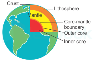
- Core, mantle, and crust are divisions based on composition.
- The crust makes up less than 1 percent of Earth by mass, consisting of oceanic crust and continental crust is often more felsic rock.
- The mantle is hot and represents about 68 percent of Earth’s mass.
- Finally, the core is mostly iron metal and makes up about 31% of the Earth. Hence Option C is the correct answer.
Geography Question 5:
Breeding work on sugarcane is being done at -
Answer (Detailed Solution Below)
Geography Question 5 Detailed Solution
The correct answer is Coimbatore.
 Key Points
- The Indian Council of Agricultural Research (ICAR) operates multiple Sugarcane Breeding Institutes across the country.
- These institutes focus on developing improved sugarcane varieties with traits such as high yield, disease resistance, and adaptability to different agro-climatic conditions.
- Some notable SBI locations are:
- Sugarcane Breeding Institute (SBI), Coimbatore, Tamil Nadu.
- Sugarcane Research Station, Karnal, Haryana.
- Sugarcane Research Station, Cuddalore, Tamil Nadu.
- Sugarcane breeding involves a combination of traditional breeding techniques and modern biotechnology approaches to develop sugarcane varieties that are resilient, high-yielding, and well-suited to local agricultural conditions.
- The goal is to enhance the productivity and sustainability of sugarcane cultivation in India.
 Additional Information
- The Indian Council of Agricultural Research (ICAR) is an autonomous organization under the Department of Agricultural Research and Education (DARE), Ministry of Agriculture and Farmers Welfare, Government of India.
- Established on July 16, 1929, ICAR is the apex body for coordinating, guiding, and managing research and education in agriculture and allied fields in India.
Top Geography MCQ Objective Questions
Earth’s core is mainly made up of ______.
Answer (Detailed Solution Below)
Geography Question 6 Detailed Solution
Download Solution PDFThe correct answer is nickel and iron.
Key Points
Core:
- The innermost layer is the core with a radius of about 3500 km.
- The central core has a very high temperature and pressure.
- The inner core (1200 km) is in the solid state whereas the outer core (2300 km) is in the liquid state.
- The innermost layer is the core with a radius of about 3500 km and divided into Inner and Outer core.
- The inner core is with a radius of 350 km mainly made up of- nickel and iron. The innermost layer is also called ‘nife’ (ni - nickel and fe - ferrous- iron).
Additional Information
The Earth is divided into four main layers: the solid crust on the outside, the mantle, the outer core, and the inner core.
- All those layers are separated from each other through a transition zone.
- These transition zones are called discontinuities.
- Conrad Discontinuity: It lies between the Upper crust and Lower crust.
- Mohorovicic Discontinuity: It lies between crust and mantle.
- Repiti Discontinuity: It lies between the Upper mantle and Lower mantle.
- Gutenberg Discontinuity: It lies between core and mantle.
- Lehman Discontinuity: It lies between the upper core and lower core.
Interior of the Earth:
Crust:
- The uppermost layer over the earth’s surface is called the crust.
- It is the thinnest of all the layers.
- on the continental masses, It is about 35 km and on the ocean floors, only 5 km.
- The crust is the thinnest layer of the Earth and it amounts to less than 1% of our planet's volume.
- The earth is made up of several concentric layers with one inside another, just like an onion.
- The crust is the outermost layer of Earth and is made up of igneous, metamorphic, and sedimentary rocks.
- The Earth's crust is unstable because of the exogenic forces.
Mantle:
- The Mantle extends up to a depth of 2900 km below the crust.
- It is the widest section of the Earth.

Which of the following is the closest layer to the Earth's surface in which all weather occurs?
Answer (Detailed Solution Below)
Geography Question 7 Detailed Solution
Download Solution PDFThe correct answer is Troposphere.
Key Points
- The troposphere is the lowest part of the Earth's atmosphere in which all tropical changes take place.
- It contains about 75% of the total air in the atmosphere.
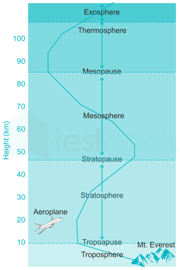
- Based on temperature variation, our atmosphere can be classified into the following layers mainly.
- Troposphere: From Earth's surface up to 10km. Here, temperature decreases with increasing height. We, humans, live in the troposphere, and nearly all weather occurs in this lowest layer. Most clouds appear here.
- Stratosphere: From 10km above the surface to 50km above the surface, Here, temperature increases with increasing height due to the presence of the ozone layer.
- Ozone gas is capable of absorbing harmful UV rays and due to the absorption, the temperature increases.
- All the airplanes fly in this zone as due to high temperature there is less turbulence and hence smoother flights are possible.
- Mesosphere: From 50km above the surface to 85 km above the surface. Here, the temperature again decreases with increasing height. Most meteors burn up in the mesosphere.
- Ionosphere: Beyond 85km there is a thermosphere layer and Ionosphere is a series of regions in parts of the mesosphere and thermosphere.
Which one of the following scholars coined the term ‘Geography’?
Answer (Detailed Solution Below)
Geography Question 8 Detailed Solution
Download Solution PDFThe correct answer is Erathosthenese.
Key Points
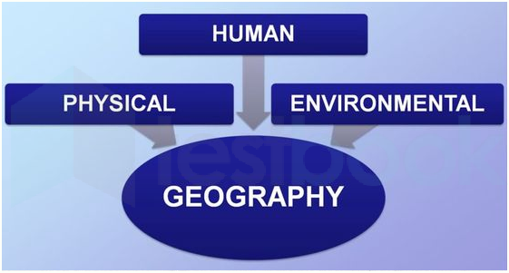
- The term ‘Geography’ was first coined by Eratosthenes.
- It is the combination of two Greek words, Geo (the earth) and Graphos (to write).
- Geography is the study of the Earth’s landscapes, peoples, places and environments.
- Physical Geography is the study of natural things like Volcanoes, earthquakes; rivers, oceans, glaciers; soil, water, air; weather and climate etc.
- Human Geography is the study of people, settlements, transport, industry etc.
- It examines how humans adapt themselves to the land and to other people, and in macroscopic transformations, they enact on the world.
- Environmental Geography is the combination of Physical and Human geography.

Additional Information
- Herodotus: Herodotus is known as the “Father of History.” and is well known for his historical accounts.
- Galileo: He was an Italian scientist and scholar whose inventions included the telescope.
- His discoveries laid the foundation for modern physics and astronomy.
- Aristotle: He was an Ancient Greek philosopher and scientist and his works are in fields of politics, psychology and ethics.
Which is the most suitable cash crop for black soil?
A. Cotton
B. Tea
C. Jute
D. Oilseeds
Answer (Detailed Solution Below)
Geography Question 9 Detailed Solution
Download Solution PDFThe correct answer is Cotton.
- Cotton is the most suitable cash crop for black soil.
- The largest producer of cotton in India is Maharashtra followed by Gujarat and Telangana.
- The largest producer of cotton in the world is India followed by China and the United States of America (USA).
- The cash crop is also known as profit crop is an agricultural crop that is grown to sell for profit.
- Some examples of cash crops are tea, coffee, rubber, coconut, and spices.
- Black soil which is found in India is rich in metals such as Aluminium, Magnesium, Lime, Calcium, and Iron.
- It is deficient in Phosphorous, Potassium, Nitrogen, and organic matter.
- The black soil is also called regur and black cotton soils because cotton is the most important crop grown on these soils.
- This soil is mainly found in Tamil Nadu, Maharashtra, Gujarat, Madya Pradesh, Andhra Pradesh, and parts of Karnataka.
- It has the highest water-retaining capacity.
- The texture of the black soil is Clayey.
Image of Cotton:

Which one of the following disciplines attempts temporal synthesis?
Answer (Detailed Solution Below)
Geography Question 10 Detailed Solution
Download Solution PDFcorrect answer is History.The
Key Points
- Temporal synthesis is defined as the automated construction of a system whereby we develop a temporary specification and then try to prove it.
- It is done in history as a discipline.
- It refers to the comparisons made with respect to the passage of time.
- Here, if a process is temporally extended, it means that it happens over a period of time.
- If the occurrence of two events differs temporally, then they happened at different points in time.
Additional Information
- Spatial synthesis is attempted by Geography.
- It includes any of the formal techniques which study entities using their topological, geometric, or geographic properties.
Consider the following statements and identify the layer of the atmosphere:
A. This layer is free from clouds.
B. This layer is ideal for flying airplanes.
C. It contains a layer of ozone gas.
Answer (Detailed Solution Below)
Geography Question 11 Detailed Solution
Download Solution PDFThe atmosphere around the earth:
- The atmosphere consists of different layers with varying densities and temperatures.
- The column of the atmosphere is divided into five different layers depending upon the temperature condition.
- They are troposphere, stratosphere, mesosphere, thermosphere, and exosphere.

Stratosphere:
- It is suitable for flying aircraft because this layer is almost free from weather disturbances.
- It extends from tropopause up to 50 km of height.
- It is an extremely dry region and almost no clouds are present in it except cirrus and mother of pearl clouds.
- The ozone layer is found in this layer.
- The ozone layer absorbs UV rays and safeguards the earth from harmful radiation.
Thus, it is clear that the statements describe the Stratosphere.
Key Points
- Troposphere:
- It is the lowermost and the most important layer of the atmosphere, as almost all the weather phenomena occur in this layer.
- It extends from the earth's surface up to 8 km over the pole and 18 km over the equator it means, the troposphere is thick over the equator than over the pole. the first 1.5 to 2 km height of the troposphere is called the friction layer.
- The troposphere is not suitable for flying aircraft, because bumpy air pockets are present in this layer.
- Mesosphere:
- It extends from 50 km to 80 km in height.
- In this layer, temperature decreases with height, and at the end of this layer, temperature becomes -100°C, which is the minimum temperature of the atmosphere.
- Thermosphere:
- It extends from 80 km to 400 km in height and it is the thickest among above all layers.
- In this layer, most of the gases are present in an ionized state and electrical conductivity is responsible for reflecting the radio waves and other electromagnetic waves back to the earth's surface.
The total length of India’s coastline is
Answer (Detailed Solution Below)
Geography Question 12 Detailed Solution
Download Solution PDFThe correct answer is 7516.6 kms.
Key Points
- Coastline of India
- The peninsular part of India extends towards the Indian Ocean.
- This has provided the country with a coastline of 6,100km on the mainland.
- The total length of the coastline of the mainland, Lakshadweep Islands, and Andaman & Nicobar Islands are 7,516.6 km.
- India's coastline extends to Nine states (Gujarat, Maharashtra, Goa, Karnataka, Kerala, Tamil Nadu, Andhra Pradesh, Odisha, and West Bengal) and four Union Territories (Puducherry, Lakshadweep, Daman & Diu, and Andaman & Nicobar Islands).
- Gujarat has the largest share (23%) in India's coastline, followed by Andhra Pradesh and Tamil Nadu.
Additional Information
| State | Coastline (in km) |
| Gujarat | 1214.70 |
| Andhra Pradesh | 973.70 |
| Tamil Nadu | 906.70 |
| Maharashtra | 652.60 |
| Kerala | 569.70 |
| Odisha | 476.70 |
| Karnataka | 280 |
| Goa | 101 |
| Andaman Nicobar | 1912 |
Which of the following is the outermost layer of the atmosphere?
Answer (Detailed Solution Below)
Geography Question 13 Detailed Solution
Download Solution PDFThe correct answer is Mesosphere.
Key Points
- The mesosphere is the outermost layer of the atmosphere among these all options.
- Among all layers of the earth's atmosphere Exosphere is the outermost layer.
- The mesosphere is the third layer of the atmosphere, directly above the stratosphere and directly below the thermosphere.
- In the mesosphere, temperature decreases as altitude increases.
Image: 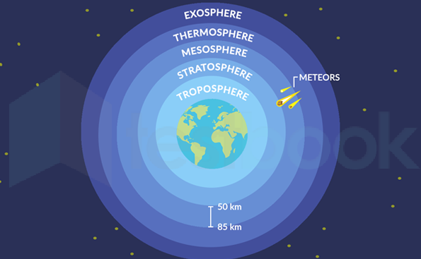
Important Points
- The Ozone layer is in Stratosphere.
- Planes generally fly in Stratosphere.
- The stratosphere is about 5 kilometres from the ground.
Additional Information
- The asthenosphere is the highly viscous, mechanically weak, and ductile region of the upper mantle of Earth.
- The lithosphere is the rocky outer part of the Earth.
- The troposphere is the bottom-most layer of the Earth's atmosphere.
Which of the following is NOT a desert in India?
Answer (Detailed Solution Below)
Geography Question 14 Detailed Solution
Download Solution PDFThe correct answer is the Indus valley desert.
Key Points
- The Indus Valley Desert is an almost uninhabited desert ecoregion of northern Pakistan.
- It covers an area of 19,501 sq km in northwestern Punjab Province between the Chenab and Indus rivers.
- It is drier and less hospitable than the northwestern thorn scrub forests that surround it with temperatures ranging from freezing in winter to extremely hot in summer with only 600-800 mm of rainfall per year.
- The desert is home to five large mammals: Indian wolf, striped hyena, caracal, Indian leopard, and the urial along with many rodents and other mammals.
Additional Information
- The Thar desert
- The Thar Desert is located in India (Rajasthan) and is also known as the Great Indian Desert.
- The Thar Desert extends between the Aravalli Hills in the northeast and the Rann of Kutch in the west and the alluvial plains of the Indus River in the northwest.
- It is located partly in the Rajasthan state of India and partly in the Punjab and Sindh provinces of Pakistan.
- Rann of Kutch
- The Great Rann of Kutch is a salt marsh in the Thar Desert in the Kutch District of Gujarat.
- It is divided into the Great Rann and Little Rann.
- The history of the Rann of Kutch began with early neolithic settlements. It was later inhabited by the Indus Valley Civilization as well as the Maurya and Gupta empires of India.
- Spiti valley cold desert
- Spiti Valley is a cold desert mountain valley located high in the Himalayas in the northeastern part of the northern Indian state of Himachal Pradesh.
- The name "Spiti" means "The middle land" i.e. the land between Tibet and India.
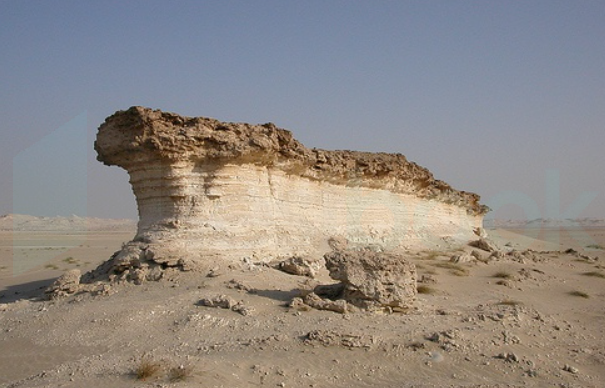
Which landform is produced by wind erosion?
Answer (Detailed Solution Below)
Geography Question 15 Detailed Solution
Download Solution PDFThe correct answer is Zeugen.
Key Points
- Zeugen landform is produced by wind erosion.
- Zeugen:
- It is table shaped landform.
- Mostly seen in arid and semi-arid regions.
- The softer part of the rock is eroded by wind and the harder part remains as it is.
Additional Information
- Cirque:
- Cirques are formed by glacier erosion.
- Cirques are amphitheater-shaped valleys with precipitous walls.
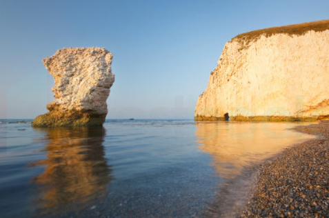
- Stacks:
- Stacks are formed by coastal wind and water waves.
- Generally seen in coastal areas.
- The formation of Stacks takes a very long time.